![]()

![]()
April-May 2005 in Italy and Malta
Click on any thumbnail to see a larger image
Pages
April
17-22 Rome
Arrival in Rome,
Tourists in
Rome
April
22-24 Bay of Naples
Herculaneum,
Sorrento,
Vesuvius
April 24-27 Capri
April
27-29 Amalfi to Maratea
Amalfi Coast and
Paestum,
Maratea
April
29-May 3 Sicily
To Sicily,
Sicily (Taormina),
Mosaics at Villa Imperiale
di Casale,
Etna,
Valley of the Temples,
Siracusa
May
3-6 On
Malta
Blue Grotto and Temples,
Valetta
and Archaeological Museum,
Exhibits in Archaeological Museum
Hypogeum,
Gozo and Ggantija,
Tarxien
and Clapham Junction
May 6-7 Sicily, Scilla and Charybdis
May 7-8 Tropea (Capo Vaticano)
May
8-10 Puglia
Matera,
Grotto, Trulli of Alberobello
May 10-12 Abruzzi National Park
May 12 Tivoli, Villa Adriana
Maratea
 |
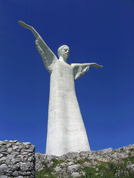
Looking up at the Christ statue from Marina di Maratea |
 |
 |
| Entrance to Maratea, and its main street. |
Maratea is an old coastal town just south of the Campania-Basilicata border. It has several satellite towns spread about 20 km along the coast with Maratea in their name, including Aquafredda di Maratea, Marina di Maratea, and the town in which our hotel was, Castrocucco. Actually. Maratea isn't itself on the coast. It a hundred or more metres above Marina, and a kilometer or so inland.
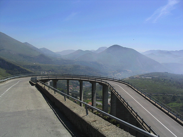
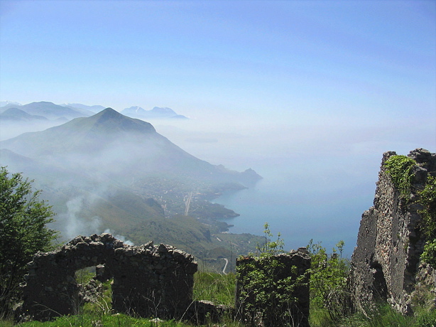
Maratea is dominated by a high bluff, on top of which is a 20m statue of "Christ the Redeemer" with outstretched arms, much like the Christ on the mountain in Rio de Janeiro. One can drive up to it, which we did (extremely slowly around some of the hairpin turns suspended in mid-air on viaducts). The views from there are superb, especially looking south along the coast, with the mid-level of the mountains wreathed in mist. (Castrocucco is just beyond the last headland you can see in the picture).
 |
 |
 |
 |
| One of the many suspended hairpin turns on the way up. | Marina di Maratea from the Christ statue. | Looking south along the coast from the Christ. |
 |
| The upwelling spring of cold water that gives Aquafredda its name |
From Maratea, we took a drive north (or west, if you prefer) along the coast, past Aquafredda and Sapri, which is the main town of the Gulf of Policastro, into the hills of the National Park. Aquafredda means "Cold Water". It takes its name from a powerful underwater spring in the bay. During our 1991 meeting, the hotel owner took several of us out for swimming in the 28°C water, and towed us through the upwelling pool, which was quite a shock to the system, at, I think, 16°C.
The road between Maratea and Aquafredda has much improved since my 1991 meeting in Aquafredda. Now it is a well maintained road wide enough for two cars at all points, though it still goes around the cliff corners in dangerously sharp turns. Before the car road was built, it was a donkey track. The story is that if a donkey driver going to Maratea met one going to Aquafredda, they couldn't pass one another, so they negotiated. One of the donkeys was pushed over the cliff into the sea, and the other driver paid for it.
 |
 |
 |
 |
 |
| On the way to Sapri | Overlooking the Gulf of Policastro and Sapri | Hills above Aquavena | Roccagloriosa from Aquavena | A cemetery. The large "houses" are family mausolea. |
The road from Maratea to Sapri is similar in places, but there are fairly long stretches of quite normal road, too. Beyond Sapri, the coast road does not continue very far. One has to go back or go into the hill country of the National Park, which is what we wanted to do. We took a short loop past Aquavena and Roccagloriosa, on a road that was signed as being "distressed" several times along the way. Usually that meant that a good piece of the road was slumping towards the valley below.
As we returned from the trip, by the same road, we saw different views, including the start of our next day's drive. It was only then that we discovered why we couldn't see the sea from our hotel. We were separated from it by about a kilometer and a half of flat fields.
 |
 |
 |
 |
| Looking south toward Castrocucco di Maratea (left of picture) | The beach road was a protection against flash floods. There was lots of bamboo in the flood plain. | Road to the beach. The goats seemed as if they were part of the family. | Black sand beach, looking south to where we were about to go. |
To finish the day, we wandered down to the beach along a road that obviously was built for great crowds of beach-worshippers, with wide separate lanes for cars, bicycles, and pedestrians. The road paralleled a river that drained through the inland gorge, and there were many signs warning people not to go toward the river in case of flash floods when an upstream hydor-electric dam might be opened. The area between the road and the river had large stands of tall bamboo, several of which had been burned.
![]()
![]()