![]()
![]()
 |
|
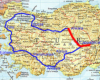
Click on any name on the route to go to the story
for that place
|
 |
| A stele in the Ankara museum covered with hieroglyphs. The picture is highly enhanced, because in the original the stone looks flat white. The big version is bigger than most in this holiday web site, so that the hieroglyphics can be seen. |
We started the day be taking the bus through Ankara, including some of the old town, but also past big plazas with considerable traffic. The target was the Archaeological Museum. It is a fine museum, well laid out chronologically to give a feeling of the development of human habitation in Asia Minor. There are some amazing things, especially from the Bronze Age.
I tried to take pictures, but flash was not allowed. However, the battery was really dying, and sometimes the pictures would not take at all. Once the flash went off when I told it not to, much to the annoyance of a guard. Here's a verions (much enhanced) of the picture it took of a stele with Luvian (?) hieroglyphics. Luvian is sometimes conjectured to be the language of Minoan Linear A.
 |
| A Bronze from 2500 BC found in the region of Ankara. (Museum replica) |
Just from looking at the hieroglyphics, one might guess that this is a milestone of some kind. There are 6 rows of writing that run around the column. on one of the middle rows, there is a lower leg, a patch of strokes that in Mycenean Linear B would mean "9" and also a picture of a horse or donkey head. More apparent numbers are on the row beneath.But then again, it could be something quite different. There are dozons of other symbols covering pretty well the whole stone as well as its base, most of them much more abstract.
The Craftsmanship of the Bronze age things was quite remarkable. At the museum shop I bought a replica of a small statue group of three deer, one with big antlers, inside a ring of spiral metal 4500 years ago. It is quite beautiful. The Ankara people must think so, too, because there is a 3-meter high replica of it on one of the main avenues in the city.
The writings that were labelled Hittite seemed most interesting. Some were hieroglyphics (maybe the stele is Hittite rather than Luvian) and some are in a more formal cuneiform.The hieroglyphics were apparently the more popular writing form. Some of the hieroglyphics seemed to mimic some of the Mason's Marks from Phaestos and Malia. Overall, they were written much less rigidly than the Egyptian hieroglyphics, though one or two of them may be the same as the Egyptian forms.
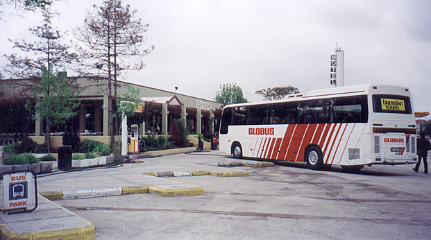 |
| A typical lunch stop. This is the one where I had a nice experience in buying a camera battery. |
At the museum, the camera had refused even to close after taking one picture. The battery was truly dead.
We had a rest stop in a substantial town whose name I have forgotten, and had time to walk around in a shopping area, but did not find anywhere that seemed to sell the right kind of battery. However, we stopped again for a short break, at a highway rest stop at Aksaray, and in the shop there they had the right kind of battery.
Buying the battery led to a very pleasant experience. The battery code had a "2" at the end of it, and in selecting the battery with the shopkeeper, I said "2" intending to distinguish it from the one that had "3" at then end of its code. I asked how much, and he said 12,000,000, which was OK, if a little more than I expected. So I took my battery and left to browse around the shop a bit. After a few moments, he came after me to give me 6,000,000 back. When he said 12 million, he had thought I wanted two batteries. This was not the last time we met with that kind of honesty on our trip. It leaves a good taste, and was quite a contrast to our lunch experience in Istanbul a few days earlier.
The landscape we passed was mostly rolling and dryish, either barren or in wheat. We passed the Great Salt Lake, which has a wide flat littoral that presumably it used to cover when the climate was wetter (such as during the Ice Age). The water was nearly up to the road along a stretch of many kilometers, but Ahmet said that in the summer it dries back so that you may not be able to see the lake shore from the road. A couple of days later, we passed south of it on the way to Konya, and the land was as flat as anything on the Canadian Prairie, presumably also having been for a long time under the lake.
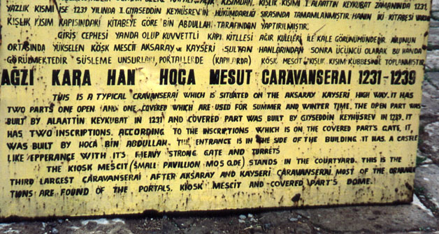
We stopped at a caravanserai on the way to Cappadocia. A caravanserai is a kind of fortified hostelry. There used to be strings of them at separations of about one day's travel for a camel caravan along the main trading routes. They were paid for by the state. A camel caravan could stay there free for a maximum of three days to rest and conduct business. This is the sign outside the one we stopped at.
 |
|
The explanatory sign outside the caravanserai we
visited.
|
The layout of a caravanserai was apparently somewhat standardized. There were two square areas inside the fortification wall, one covered (the winter part), the other (the summer part) open to the sky with a small "kiosk" in the middle, the upper floor of which served as a mosque. Within the outer wall of the summer part was a covered portico for shade, with offices, eating rooms, and shops in the wall. The winter part was arranged with a central aisle, and a double portico on each side, which made patches for the individual camel caravans. The stench must have been amazing when there were five or ten caravans in residence, with all the camels quartered in the porticos!
 |
 |
 |
 |
| The caravanserai: (1) The outer wall and main entrance. (2) The door from the summer part to the winter part. (3) Inside the winter part, showing two of the partition walls between the individual caravan patches. (4) around the corner at the far end of the wall in the left picture, some children of the local village pose for pictures. (mouse over it to see what those mounds are (Javascript required)). | |||
Outside the caravanserai there is a village of rather tumble-down cottages of volcanic tufa rock, which is easy to cut and carve. It is a big contrast to the modernity of Ankara. But then, Turkey is a land of big contrasts in so many of its aspects. Camels are part of daily life here, and became more in evidence as we went further east.
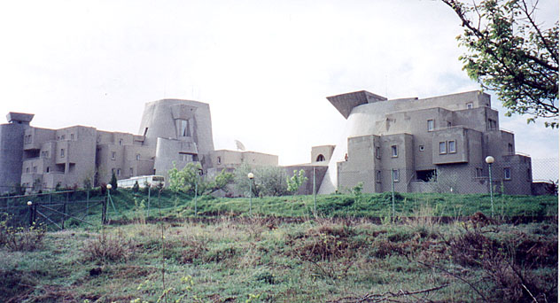 |
| Peri Tower Hotel, built to mimic the dwellings cut into the volcanic rocks in Cappadocia. |
As we drove on, slowly climbing to higher elevations, it began to rain, and then to snow. For a while we passed through patches in which the snow was lying--this in early May! Ahmet said that he had never seen snow in this area at this time of year. The rain got heavier and heavier until we reached the Peri Tower Hotel in Nevs.ehir (remember "s." indicates the Turkish s with a dot under it, pronounced sh). Peri means "fairy" (in the sense of magical little people).
The hotel is as strangely configured inside as out. Outside, it is supposed to be an abstraction of the dwellings and churches cut into the rock mounds that we were going to see the next day. Inside, it is all concrete in curves and shifting levels. There is a big open central area, but that is not where the lobby is. The central area is flanked at different levels by balconied walkways connecting the different levels, and it is quite easy to come from the restaurant and find yourself on a level different from the one you intended. There's no sense of there being a ground floor, a first floor, and so forth. The effect is visually great, but acoustically it is terrible, with curved reflective surfaces everywhere to focus teh sound in odd ways.
The restaurant is worse, acoustically. It is a concrete circle with no acoustic absorbers other than the people, so the noise is terrible, with dozens, if not hundreds of people all shouting to be heard by the person sitting next to them. It would be so easy to fix that problem without in the least detracting from the visual appearance--a few cheap but good looking wool-on-wool Turkish carpets hung around the walls would make a huge difference.
After exploring this strange hotel for a bit, Ina and the other Canadian couple went for a walk in the rain, which had eased off a little, to the town of Nevs.ehir, perhaps a kilometer away across a valley. I joined a small group at the bar in the central court, and bit by bit more individuals and couples joined us. As each new one came, the waitresses would bring additional little round tables until we had quite an elaborate table-cluster, matching the curvilinear theme of the hotel itself.
 |
| A pottery tree and fountain in a village that specialises in pottery. |
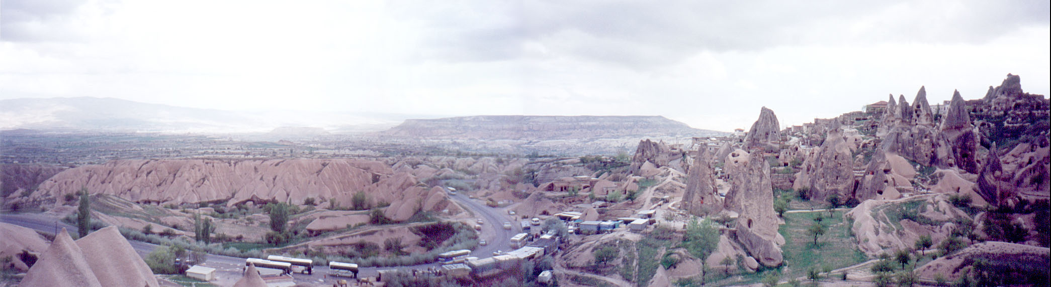
Today we toured the sights of Cappadocia, which are based on the properties of tufa, compacted volcanic ash. On our way there, we passed through a village that specialised in pottery. The next day we were to visit a fine pottery factory, but today the interest was on bigger things.
Cappadocia is between two big extinct volcanos, which over a period of a million years or so spread ash over the territory. Unfortunately, we didn't see the volcanos because of the low cloud, except for a brief glimpse of the lower slopes of one of them as we were leaving the region a couple of days later. But we did see the ash layer--the tufa--which is like the Santorini ash layer. Now it is like soft rock, soft enough that one can scrape it with a fingernail. However, on the surface, you wouldn't guess what is underneath. It looks like very pleasant rolling countryside.
 |
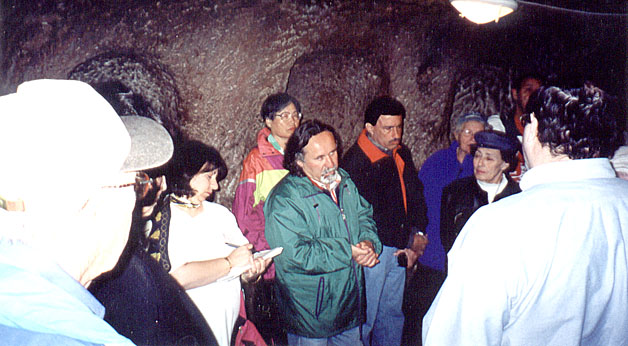
| We are standing on top of one of the smaller Cappadocian underground cities, called Özkonak. |
When we arrived at our first destination, nobody would have guessed that under our feet was a city where 5000 people could hide for 6 months without coming up for supplies. But that's what they did in the 7th and 8th centuries when the area was subject to marauding bands of Arabs. The only defence was to pretend not to exist. If the Arabs found an entryway, they could smoke out the inhabitants, but if they didn't, everyone was safe. The people hiding underground could even make wine from stored grapes in large stone tanks that were carved out of the rock
Özkonak was one of the smaller underground cities. Others could hold 25,000 people, and in all, perhaps 100,000 could hide underground for months at a time. No invader could fight their way in, for two reasons. Firstly, the tunnels between the rooms were wide enough only for one person at a time, so each invader could be killed as he emerged into any room, and secondly, the tunnels had "doors" that consisted of stone wheels carved in situ out of the living rock, which could be rolled into place and then jammed with a small rock so that nobody on the tunnel side could move them. Ahmet said that one of the rooms of a comfortable size to live in could be dug by one person with a metal trowel in a week.
 |
 |
 |
| In the underground city. (Left) One of the tunnels between rooms. You can see the scratch marks on the wall from the digging tool. (Middle) Our guide, Ahmet, explaining how and why the underground cities were built. You can see two tunnels in the background. (Right) One of the big stone disks cut in place from the living rock to be rolled across the tunnel mouth as an impregnable door. The arrow over the tunnel mouth indicates the way out to the surface. | ||
 |
| The Cappadocian countryside. |
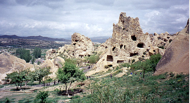
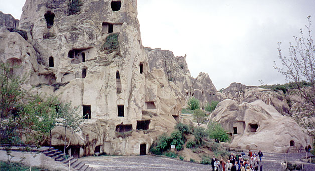
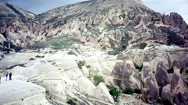
From the underground city, we drove to the Göreme open-air musem. The countryside is pretty, but doesn't look particularly dramatic on the road to the museum. That changes quite suddenly.
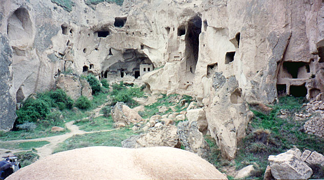
It isn't really a museum. It is a region of weird hills and cliffs created in the tufa by erosion. In the cliffsides, people have dug dwellings and churches over the last two thousand years. Some of the early Christians came here to avoid persecution. There are lots and lots of churches, many with frescos. One of the frescos shows three saints along with a man in a turban, presumed to be a local governor welcoming the Christians. In the churches, most of the frescos have been damaged by various kinds of people, not least the Moslems who thought it sacriligeous to show the faces of saints.
In these pictures, you can see many square cuts in the rock. Originally, these were rooms inside the rock, perhaps with a tunnel access from further inside, perhaps with a door to the outer world. But the tufa rock weathers badly, and slices fall off over the years, leaving the inner room open to the outside. You can see clearly the way the rock has fallen away in the picture of the big church. On several of the rock faces there were rows of little square holes, which Ahmet said were pigeon boxes, accessible from tunnels inside the cliff face.
The churches are sometimes quite small, allowing only part of our group of 44 to be inside at one time. But others were much larger, as you can see in the picture with the girls. The were considerable crowds everywhere, meaning that we often had to wait in the light rain outside one or other of the little churches waiting for one group to leave so that our group could get in.
 |
 |
 |
| The Göreme Open Air Museum. (Left) view down past the eroding rock pillars. (middle) Many of the rooms, most of which were churches, have been eroded open to the outer world. (Right) Several of the churches. | ||
 |
| These girls were having their picture taken by their boyfriends. This church must have been almost a cathedral! |
The lower picture shows the same church as at the left of the upper-right picture. When we got there a group of girls was posing for a group of boys. The girls are wearing a style of dress we saw quite often, although we also saw both more Western dress and more strict Islamic dress, including the full chador. It seemed that women could wear what they felt like wearing, and many chose this rather attractive "raincoat and headscarf" outfit.
We drove some distance for lunch, by a rather circuitous route that allowed us to appreciate the "watchtower." This substantial hill is said to be honeycombed and to be part of one of the underground cities. I'm not sure, but possibly the rooms now exposed in the right side of the left picture (below) were also connected to the city.
 |
 |
 |
| (Left and middle) The "watchtower". The hill is apparently almost completely hollowed out. From it, guards would watch for approaching Arabs, and warn people to dive into the underground city to which it connects. (Right) Behind the watchtower, a man offers camel rides. In the rock cones you can see (in the larger version) many rooms, some almost entirely eroded away. | ||
The crowd problem persisted at lunch. There were 5 buses and many cars at the restaurant where Ahmet had intended we should eat, so we went to another place close by. The food was not very good, but the view on the other side of the road from both places was spectacular. The middle picture above shows part of that view down a steep gully (naturally with dug-out rooms) toward the watchtower.
After lunch, we went around to the other side of the watchtower, where there were many dugout dwellings in the tufa cones, one or two of them apparently still used. There were quite a few buses there, as you can see in the panorama picture. And there were people offering camel rides, as there had been at the Open Air Museum.
 |
| A panorama of the scene on the other side of the watchtower, which is at the far right. Click on the picture to get a scrolling version. |
In many of the pictures you can see dark and light-coloured rock. Where the rock has weathered and been exposed to rain for a while, it goes dark. The lighter patches either are sheltered from the rain or have recently been eroded away. You can see the effect in these postcard pictures, taken on sunnier days.
 |
 |
 |
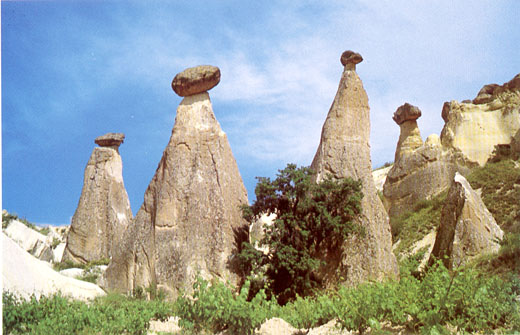
| (Left and Middle) Postcards showing how the cones are formed. Especially in the middle picture you can see the protective effect of the hard rock cap on the colour of the tufa. (Right) In the larger version of this picture, you can see three rows of tufa cones (none of them lived-in). The bottom-right set is the one shown in the middle (postcard) view. | ||
The postcards illustrate how the rock cones are formed. The tufa is originally covered by a layer of hard rock, perhaps a lava flow. Over time, water erodes cracks in the overlying rock, and then rapidly erodes the soft tufa below the crack. Parts of the hard rock break off because they no longer have support, and where it is unprotected the tufa erodes down to its base, leaving the cones with hard rock caps. Finally, the hard cap falls off and the cone rapidly erodes down to the ground.
There are several tufa layers separated by hard rock, laid down over millions of years by the big volcanos, so there are families of tufa cones. In the picture at right above, three such families are visible: one at the bottom, which is the same as the one shown in the right-hand "sunny" postcard, one near the top of the hill, with a prominent red band running through it, and one partially visible below the upper one in the right half of the picture. I don't have a picture of it, but from this vantage point one can see all the stages of development of the lowest family. In the picture, the people at the left are standing on an unbroken surface of teh harder rock, which has been eroded away to form the cones at the right. The same has happened out of the picture to the left, and as one looks further and further leftward, one sees ever smaller cap-rocks and then progressively eroding cones, down to the plain at the bottom of the valley.
 |
 |
| Some of the rock rooms in the Zelva cliffs. In the left picture, you can see some of the huge chunks of the cliff that fell. One in the middle of the picture even had most of a room in it. In the big version of the picture at the right, you can see some of the inner stariways that connected the rooms, in particular both of the centre rooms have stairways up or down. | |
While we were looking at the erosion patterns of the tufa layers, a thunderstorm was threatening. It arrived when we reached the next point of interest, a National Park called Zelva, where four valleys with cliff-sided walls radiate like the fingers of a hand from a central valley. People lived in dwellings cut into those walls until the late 1990s when the government forced their eviction on the grounds that the place was physically dangerous. They were probably right, since a year or so before our visit (presumably during an earthquake) many big sections of the cliffs had tumbled into the valleys, and at the time of our visit only one valley was open to tourists.
We braved the pouring rain to visit the one open valley. It was so dark that the camera flashed when taking an outdoor picture, but the pictures still seemed to come out. In the right-hand picture, you can see the difference between the rock surface at the back that sheared off some time ago, as compared to the fall that recently exposed the rooms at the right. We went into one of the rooms to get out of the rain while Ahmet gave a little talk about the place, and we were a bit nervous about a big crack that ran right across the ceiling, suggesting that room might be sheared off at any moment!
 |
 |
| A demonstration of potting with red clay. | Some of the expensive plates available for purchase. |
From Zelva, we went to a pottery in a cave, where we were given a lecture and demonstration of two different techniques using different kinds of clay. They make very high quality plates, pots, and tiles, many of them in classical Islamic motifs. For some of their material they have a licance with the Ankara musem that allows them to make two copies per year of some museum plates. The quality is high, but so are the prices, and we did not buy anything.
It was raining again when we left the pottery and went back to the hotel, where at dinner one of our friends was given a big birthday cake!